FAQ. Problems when searching on the coverage map: различия между версиями
Нет описания правки |
|||
| Строка 1: | Строка 1: | ||
[[FAQ._Problems_when_searching_on_the_coverage_map|en]] | [[FAQ._Проблемы_при_поиске_на_карте_покрытия|ru]] | [[FAQ._Problems_when_searching_on_the_coverage_map|en]] | [[FAQ._Проблемы_при_поиске_на_карте_покрытия|ru]] | ||
== Incorrect location == | |||
[[Файл:Map_search.png|thumb|800px|center]] | |||
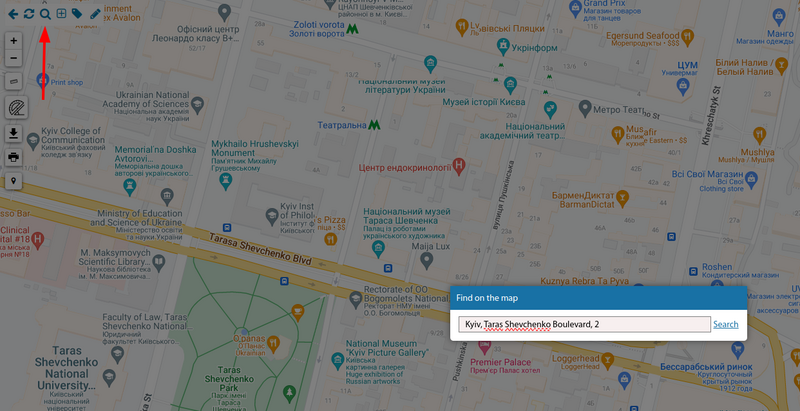
When performing a coverage map search ("magnifying glass icon") this functionality works ''exclusively'' through the external geocoder of the information systems. So it is not a search for the location of the userside objects ''(buildings, fibre optic junction boxes, nodes, etc.)'' on the map. It is a ''search for an entirely random address'' on the planet. | |||
What is this search for then? For example, to quickly find the home of a user who is not yet connected to your network. | |||
The correctness of your search depends directly on the correctness of the information you enter in the search box. It also depends on the correctness of the geo-services system databases. | |||
At the moment UserSide uses mainly the free service Nominatim OpenStreetMap. The other services ''(Google, Yandex)'' are relatively expensive for our clients and require separate agreements between clients and geo-services. | |||
== How to specify the search as precisely as possible? == | |||
https://nominatim.openstreetmap.org/ - try this service to do a search and see the results. Pay attention to the format for entering an address for your area. You may need to enter the name of the district or region, or the full name, for example, the word "street". | |||
'''We have no influence on the search formats and completeness of the information. Once again, this is all data from geocoding services.'' | |||
Версия от 17:07, 6 марта 2023
Incorrect location

When performing a coverage map search ("magnifying glass icon") this functionality works exclusively through the external geocoder of the information systems. So it is not a search for the location of the userside objects (buildings, fibre optic junction boxes, nodes, etc.) on the map. It is a search for an entirely random address on the planet.
What is this search for then? For example, to quickly find the home of a user who is not yet connected to your network.
The correctness of your search depends directly on the correctness of the information you enter in the search box. It also depends on the correctness of the geo-services system databases.
At the moment UserSide uses mainly the free service Nominatim OpenStreetMap. The other services (Google, Yandex) are relatively expensive for our clients and require separate agreements between clients and geo-services.
How to specify the search as precisely as possible?
https://nominatim.openstreetmap.org/ - try this service to do a search and see the results. Pay attention to the format for entering an address for your area. You may need to enter the name of the district or region, or the full name, for example, the word "street".
'We have no influence on the search formats and completeness of the information. Once again, this is all data from geocoding services.